Initial Field Report
of the July 4, 2003 Kekoskee / Mayville, Wisconsin Crop Circle Formation
[Aerial photo of Kekoskee / Mayville crop circle
formation facing North.]
Introduction
On July 23-24, 2003, a private scientific research team documented
physical evidence that confirmed Art Rantala’s eyewitness
observation that the Mayville/Kekoskee, Wisconsin crop circle
formation was not made by hoaxers.
The
team consisted of Gary Kahlimer of Horicon, Wisconsin, Dr.
Charles Lietzau and Jeffrey
Wilson of Michigan, and Roger
Sugden of Indiana. Arriving at the field on July 23, 2002,
we discovered and photographed the presence of several anomalies
that cannot be duplicated by hoaxers.
Eyewitness
Account
Art Rantala, a retired truck driver, on July 4, 2003 at approximately
7:30 AM Central Daylight Time (CDT), was up early making coffee
in his workshop and watching a weather front that was moving across
the Dodge County, Wisconsin area. His workshop is located a few
miles from the town of Mayville and the village of Kekoskee, and
situated at the top of a hill overlooking a wheat field across
the street (owned by a Mrs. Schraufnagel, and farmed by a third
party). Art poured his first cup of coffee at 7:35 AM CDT noticing
the time on his coffee maker. A few minutes later (approx. 7:40
AM CDT), as the rain was falling, the wind picked up, and Mr.
Rantala noticed that the bark began flying off a hickory nut tree
that was about 10 feet outside his open, East-facing workshop
window.
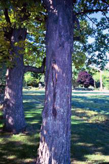
[View
from Mr. Rantala’s workshop of the hickory nut tree with
missing bark.]
He
leaned out the window to take a closer look. Mr. Rantala then
noticed that directly across the street, a group of trees “started
swinging every which-way.” He said that as he followed the
trees blowing around, his gaze naturally followed down to the
wheat field where the circles appeared one by one, right in front
of him.
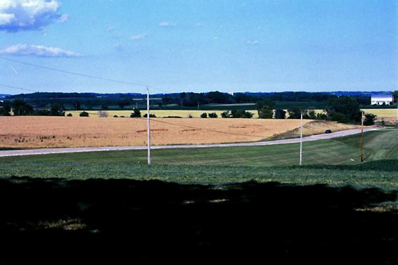
[View
of the circle formation from Mr. Rantala’s workshop window.]
The
Northern-most circle, farthest away from the road (what we have
named Circle #1 in order of appearance), formed first, appearing
as a ‘black hole’ in the standing wheat that was created
when the circle of wheat was flattened down. Next, the Southern-most
circle closest to the road formed (Circle #2), followed by the
one in the center (Circle #3). Mr. Rantala said all the circles
were flattened in roughly 12 seconds, but no more than 15 seconds.
Mr. Rantala’s important eyewitness observation to the crop
circles forming may be the first ever recorded in the USA, and
is certainly one of only a couple of dozen reported worldwide
in the last 50 years. Mr. Rantala reported that there was no apparent
means for the wheat to have been swirled and flattened –
nothing unusual in the sky, no lights, no unusual sounds, and
no unusual odors. Whatever the energetic force was that caused
the circles to form, it was beyond the range of visible sight.
Plant Anomalies
Many of the plants inside these circles, though, bear witness
to the formative energies in the form of ‘blown node collars’
or expulsion cavities. The joint or node collars were flash heated
by so much energy, that their internal moisture turned to steam
causing them to explode and rupture like popcorn. We also located
plants with blown node collars inside ‘randomly-downed’
patches of flattened wheat that were also found in the field as
far away as 500ft from the circle formation.
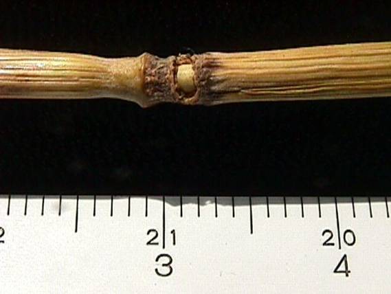
[View
of one of the many blown node collars from the flattened stalks
of wheat found inside the formation.]
Blown
node collars have never been found in any hoaxed crop circles,
nor in any control samples that have ever been studied. There
is no known technology that is able to duplicate this blown node
collar effect on thousands of plants in these downed areas of
crop fields. However, this effect has been reproduced by putting
stems into a microwave oven, and cooking them for a short time.
The appearance, then, of these blown node collars is conclusive
evidence - in itself - that these circles were not flattened by
human-mechanical means.
We
also discovered several wheat stems with ‘seed axis deformities.’
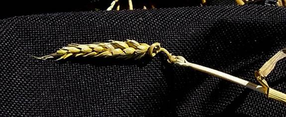
[View
of one of the stalks of wheat found in the formation with a seed
axis deformity in the stalk just below the seed head.]
These
seed axis deformities are affected sections of the stalk just
below the seed head, and have been twisted around in a ‘curly-q’
effect. This has been reported in only a few crop circles worldwide,
and was first reported in 1999 in a crop circle formation in the
UK near Avebury in Wiltshire County. This deformity has also never
been found in standing plants or control samples.
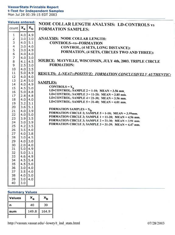
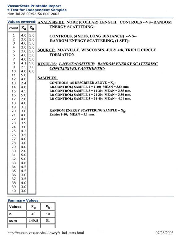
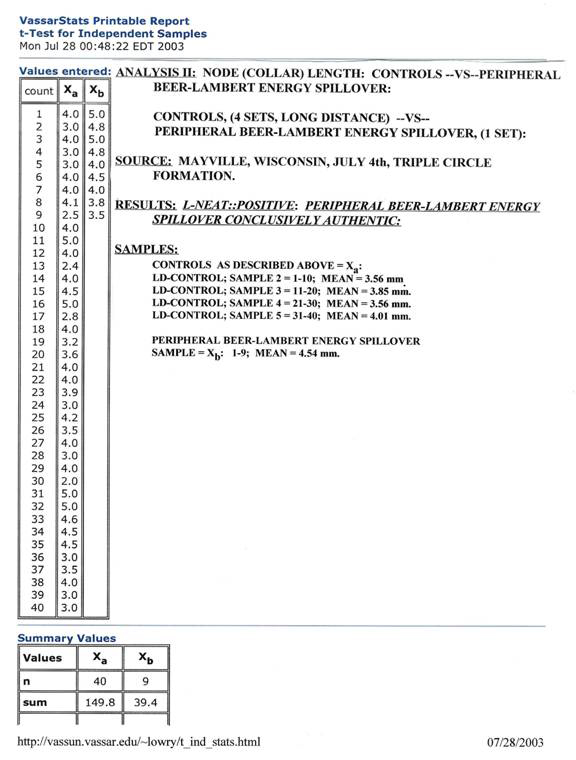
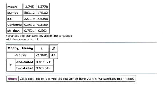
We
also followed the L-NEAT (Levengood Node Elongation Analysis Test)
scientific protocol to determine if there was a statistical difference
in the measurement of growth nodes of plants inside the circles
as compared to the measured length of growth nodes of control
plants taken from outside the circles in the standing wheat. This
test positively identified the fact that the growth nodes of plants
found inside the circles were statistically larger than the growth
nodes of plants measured from outside the circles in the standing
wheat. This elongation or enlargement of the growth nodes of these
plants cannot be duplicated by any demonstrated hoaxing techniques.
This positive result from L-NEAT test, then, independently and
conclusively confirms that no human-mechanical means were used
in the creation of these crop circles. [For the
statistical data, see the Appendix.]
Our
team also obtained plant samples and control samples for further
analysis. We also understand that plant samples were collected
by researchers from the University of Wisconsin - Eau Clare and
Madison, and have been forwarded to biophysicist W.C. Levengood
of Grass Lake, Michigan, and to Nancy Talbott of the BLT, Inc.
Research Team of Cambridge, Massachusetts. We look to them to
carry out many of the time consuming studies necessary to document
the characteristics of the formative energies, but those laboratory
results will take months, and we wanted to conclusively determine
the authenticity of the formation while it was still fresh. Bent
growth nodes in the past have been used as a determination of
the authenticity of crop circle formations, but that methodology
does not always work. Both phototropism and geotropism can cause
node bending after crops are flattened, although it has been shown
experimentally to take several days for those processes to exhibit
a noticeable growth node bending effect. Because we arrived at
the formation almost three weeks after it formed, we did not use
node bending as a criteria for authenticity, nor as it turns out,
did we need to.
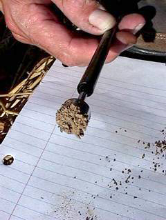
Soil
Anomaly and Sampling
Further, we carried out the collection process for obtaining soil
samples and conclusively noted another anomaly. Roger Sugden did
a preliminary field test of the soil using a magnet and discovered
that the soil showed a high magnetic response.
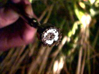
[The
left photo is of soil inside the formation which shows a HIGH
MAGNETIC RESPONSE; complete, multilayer coverage of the probe.
The right photo is of soil outside the formation used as a control
showing a low magnetic response; demonstrating incomplete coverage
of the magnet.]
As
we continued the field test, we obtained soil samples on a North-South
line across the formation, and we again tested the soil for this
magnetic effect. Every sample from inside the circles was found
to consist of soil that showed this highly magnetic response.
We also applied this test to the control samples we obtained from
outside the circles beginning with soil just outside the flattened
wheat areas, and continuing to several hundred yards away to the
back of the field. Only two of the samples close to the circle
formation showed this property of being highly magnetic, while
the others taken farther away showed signs of having some magnetic
particles but at a much lower proportion. Using the statistical
Fisher Exact Probability Test, the soil samples are significant
at p = 0.0147. This in-the-field observational test shows that
the soil inside the circles anomalously consisted of more magnetic
particles than the control soil outside the circles in the same
field. We are planning to further analyze the soil samples in
a lab environment.
GPS
Anomaly
The crop circle formation is located at approximately 43?31.81m
N latitude, and 88?31.59m W longitude. This location was confirmed
through using two different Global Positioning System (GPS) units.
However, we were unable to conclusively obtain an approximate
feet-above-sea-level measurement from within the formation. Our
attempt resulted in a constantly changing measurement ranging
from –242ft below sea level to over +1142 ft above sea level
(the area is approximately +566ft above sea level). This effect
on the GPS system was witnessed by the entire team and videotaped.
The effect was not noted in GPS control readings taken from outside
the formation. Noting the anomaly, we carried out a statistical
test from several areas from within Circle #2 and compared them
to readings taken with the GPS from outside the circles that conclusively
determined the anomalous effect existed.
Considering
that our team arrived nearly three weeks after the crop circles
formed, we did not expect to find the presence of any residual
Electro-Magnetic anomalies. In fact, we did conduct a preliminary
Electro-Magnetic field measurement soon after arriving at the
location. We took measurements from inside the formation and from
outside the formation which showed no elevated measurements of
either electric field strength or magnetic field strength. So,
due to time constraints, and considering our past experience of
not finding high E-M readings more than approximately 10 days
after circle formation, we abandoned those tests. It was only
later that we noted the GPS anomaly, which remains unexplained,
and may not have been caused the presence of high Electro-Magnetic
fields, but by some other undetermined cause.
Crop
Circle Formation Description and Measurements
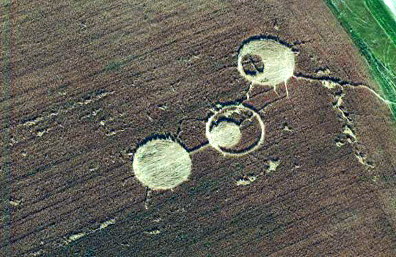
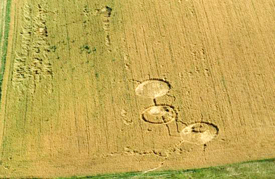
[Overhead
aerial photo of the circle formation.]
The
Kekoskee / Mayville, Wisconsin formation is interesting in several
aspects – although Mr. Rantalla described the formation
event as each circle flattening individually one by one, the three
circles are related to each other through their design form. Circle
#1 and Circle #3 are connected by a pathway that was part of the
original formation -creating a classic ‘dumbell’-type
(two circles connected by a pathway) shape aligned in a North-South
direction. Circle #2 was isolated in the field (and offset from
the N-S alignment), but was related to Circle #3 in an interesting
way. The obvious feature of Circle #3 is the standing crescent
of wheat that has been created through the offset flattening of
a circle of wheat. The obvious feature of Circle #2 is the standing
circle of wheat which then creates a flattened ‘crescent.’
Although all the circles (including the standing one) when measured
prove to be elliptical, when you compare the flattened interior
circle’s diameter of Circle #3 with the diameter of the
standing circle of wheat in Circle #2 along their NE/SW, they
both measure 22’ in diameter. Circle #2 and Circle #3 are
in alignment NE/SW. All the circles when measured along their
E/W diameter were 42’exactly.
Pathway
– measurements: 18’ long (Flattened from South to
North) by 2’2” wide.
We
believe that this formation began to be formed with this pathway.
We could clearly follow the pathway’s flattened wheat into
the lay of Circle #1, where there was a ‘ring’ of
flattened wheat that was layered over the top of it swirled counter-clockwise.
All of the wheat in Circle #1’s ‘central circle’
was flattened directly to the North, which was at the Northern-most
point flattened over the top of the flattened ring.
Circle
#1 – measurements: (‘ring’ swirled counter-clockwise,
interior ‘circle’ flattened South to North)
N/S – 42’ diameter N/S interior ring 6’6”/4’9”
N/S Center diameter 30’9”
NW/SE – 43’ diameter NW/SE int. ring 6’2”/9’
NW/SE Center dia. 27’10”
E/W – 42’ diameter E/W int. ring 8’/6’
E/W Center dia. 28’
Circle
#2 – measurements: (flattened areas swirled counter-clockwise)
N/S – 46’2” diameter N/S standing wheat dia.
17’ N/S ring to stand. 3’8”
NW/SE – 40’6” diameter NW/SE stand. wh. dia.
22’ NW/SE ring to stand. 3’
E/W – 42’ diameter E/W standing wh. dia. 17’
E/W ring to standing 8’6”
Circle
#3 – measurements: (both exterior ‘ring’ and
interior circle swirled counter-clockwise)
N/S – 40’6” diameter N/S interior ring 2’8”/4’9”
N/S Center diameter 22’
NW/SE – 44’ diameter NW/SE int. ring 3’1”/3’
NW/SE Center dia. 22’
E/W – 42’ diameter E/W int. ring 8’/6’
E/W Center dia. 23’
Circle
#3’s central point of the swirl was offset from the ‘true’
center by about 3 feet (N radius 11’, S radius 11’,
E radius 10’, W radius 13’).
There
were also many areas of ‘randomly-downed’ sections
of flattened wheat in this same field where there exhibited the
weaving and swirls associated with crop circle formation, but
without any geometric design to these areas.
Crop
Circle Location Geology and Context
The second day of our investigation began with the team splitting
up to gather additional context information. Roger Sugden rented
a plane and hired a pilot to take several aerial photos of the
formation. Dr. Chuck Lietzau and Gary Kahlimer went back to the
formation site to examine more plants and take additional samples.
I (Jeffrey Wilson) went to investigate several nearby Indian mound
formations and gather information about the area from the local
chamber of commerce in nearby Horicon, Wisconsin. The local area,
we learned is very unique, and may have had a contributing role
to play in why the crop circle formation appeared in the location
it did. Dodge County, Wisconsin happens to have one of the largest
concentrations of existing Indian burial and effigy mounds in
the United States. In relation to the crop circle formation, there
are more than 500 Indian mounds within a 15-mile radius. Nearly
all exist on private property, and most remain unmarked, unsurveyed,
and unidentified. The closest grouping of Indian mounds to the
crop circles is one of these unidentified groupings. We noted
four geometrically aligned mounds approximately 1 mile from the
formation that point in close alignment to the crop circles.
The
closest communities to the crop circles of Mayville, Kekoskee,
and Horicon all lie along the southern edge of the Horicon National
Wildlife Refuge and Ice Age National Scientific Reserve and the
Horicon Marsh State Wildlife Area. Combined, these two protected
parks make up the largest freshwater cattail marsh in the USA
– some 36,000 acres. The area is an extinct glacial lake
carved out during the last Ice Age 12,000 years ago, and had been
used by Native Americans since at least that time as a sacred
hunting ground. For thousands of years the marsh existed as a
haven for wildlife that made it attractive to the Native Americans.
In the last two hundred years, though, the marsh has undergone
dramatic changes by the white settlers to the region. The marsh
at one time was almost completely drained in an attempt to use
the land for farming, but the experiment failed. The marsh had
also been dammed up to create a 50-mile lake, but owners of the
inundated land successfully sued to take down the dam to recover
their property. Over the past few decades reconstruction and conservation
efforts have helped the marsh to recover, but overpopulation in
the area, industrial pollution, and farm runoff are again posing
as threats to the Horicon Marsh.
Also
just south of the crop circle formation are two notable geologic
formations: Ledge Park in which the Niagara (rock) Escarpment
rises up and becomes exposed from under the Great Lakes, and Iron
Ridge, a notable concentration of iron ore that was so accessible,
it became the site of the first iron mining in the Midwest. Ledge
Park is also the site of a series of Indian petroglyphs –
at least one of which was conclusively determined to align to
the rising of the sun on the solstices.
Directly
under the crop circle formation however, and in much of the general
area is a vast formation of limestone deposits, which have been
continually mined for at least the last 150 years. Crop circles
around the world have been noted to occur along aquifers, or water-bearing
rock formations, notably limestone and greensand. This appears
to be the case with this formation. The eyewitness, Art Rantala,
told us of how he had dug into the field in which the formation
was found several years ago while participating in a government
project. They dug into the ground and exposed limestone just two
feet under the soil at the bottom of the hill on which the crop
circles formed. At the top of the hill, the limestone was found
to be down just 10 feet deep.
Crop
circles have also been noted to appear near some sort of body
of water: a creek, a pond, a drainage ditch, etc, and with this
formation, water also appears to be in close proximity. Not only
does the formation occur directly above a limestone aquifer, but
directly at the bottom of the hill, West of where the formation
appeared is a drainage ditch. East of the formation, just one
field away, is the north branch of the Rock River.
Crop Circles have also been known to form in close proximity to
power lines, and again this circle site is no exception –
less than a hundred yards from the circles runs a power line,
and just up the hill, the closest transformer box was less than
100 feet from the workshop where Mr. Rantala watched the crop
circles form.
Our
research team had at this point in our investigation enough conclusive
scientific evidence as well as a body of supporting contextual
detail to show that the Mayville/Kekoskee crop circle formation
had not been hoaxed by people using mechanical means, and that
the evidence uncovered supports the eyewitness testimony given
to us by Mr. Rantala.
US
Military Visits Crop Circles
Roger Sugden and I arrived at the formation after Roger’s
aerial photo flight, meeting Dr. Lietzau and Gary Kahilmer who
were already there. We were surprised by the appearance of a military
helicopter circling the formation very low to the ground.
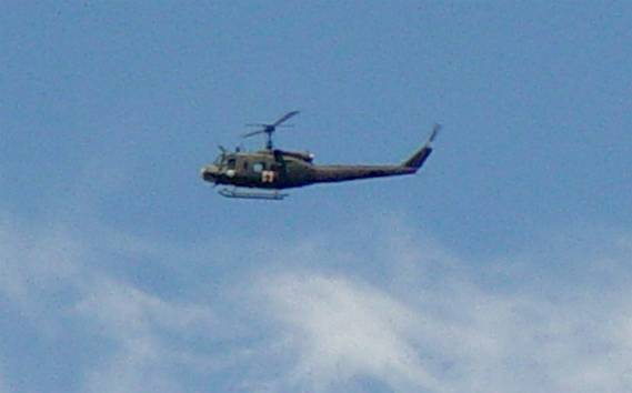
[View
of the military helicopter circling over the crop formation.]
The
helicopter circled the formation for a few minutes (with our team
in excited amazement), at which point it then flew off in the
direction of the Horicon Marsh. It looked as if it flew the length
of the marsh, and then flew back in our direction, but not as
close. It then flew off towards the Southeast where we eventually
lost sight of it. In all the crop circle reports in the USA in
my database (over 250) I have never seen one that mentioned overflights
by US military helicopters, or that the US military might be interested
in crop circle reports. Of course, we have seen this repeatedly
in the UK, but not in the USA.
After
the helicopter left and our team settled down, we returned to
gathering additional soil and plant samples from the field. After
about 40-45 minutes, I noticed that we were also under surveillance
on the ground. Looking up the hill towards Mr. Rantala’s
workshop, I noticed a man in a camouflage uniform watching us
with binoculars.
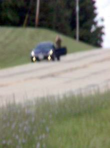
[Blurred
photo of Air Force soldier watching us with binoculars.]
After
I informed the rest of the team that we were being watched, the
uniformed soldier got into his car, drove down the hill towards
where we were parked, and slowly passed us noting our license
plates. He drove to the end of the block, turned his car around,
drove back to where we were standing and parked his car. He got
out and walked directly into the formation. Dr. Lietzau was practically
jogging after him into the field. We decided on the spot that
since we were going to publish our results on the Internet for
everyone to share, we were not going to hold back anything from
the military.
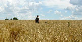
[Photo
of US Air Force soldier in crop circle.]
As
we chatted with this soldier from the US Air Force (who we had
now identified by his uniform), he told us that he was part of
a Special Crop Circle Investigative Unit in the US Air Force,
and that they had been looking into this formation for the past
couple of weeks, temporarily based out of a hanger in Milwaukee.
He also told us that this unit was originally based out of Scott
Air Force base located in Illinois (southeast of St. Louis, Missouri).
He further told us that this team had investigated two crop circles
that appeared near “Downing, Illinois” last summer
(2002), but that he hadn’t participated in that investigation
-- but others had. We had not heard of that crop circle report
in Illinois, so we are checking to verify that information. As
far as we have uncovered, there is a “Downing Park, Illinois”
which isn’t too far from Scott A.F.B., but no “Downing,
Illinois” (using MapQuest and MS Streets), so Downing Park
is what he may have meant. [If anyone has information about this
reported formation please contact us and let us know so we can
confirm this piece of information.]
I
played tour guide, and walked him around the formation -- pointing
out the various crop lay anomalies, our ideas on where the formation
began to be flattened, and how various parts of it were flattened
in which order. We told him of some of our plant anomaly findings,
and asked several questions (including a few rather silly ones)
most of which he dodged or declined to answer. I offered my contact
information to him, which he took, and our team offered to cooperate
with his investigative team by providing them with any information
we might find (and hoping they might reciprocate). I told him
that we had traveled up from Michigan, and that our investigative
report would be published on CropCircleNews.com. He said he was
familiar with the website, and believed that someone from his
team would most likely get in contact with me soon about the formation.
He said he knew we were from Michigan (most likely from our license
plates), and that their team was familiar with CropCircleNews.com.
He stayed in the formation about 10-15 minutes, at which point
he seemed satisfied, and he returned to his car and immediately
got on his cell phone, and left.
One
of the questions we asked him has left us with a nagging inconsistency:
we asked him if he had been on the helicopter when it had overflown
us about 45 minutes before he appeared. He said he had been on
board the helicopter, and that besides himself there were two
other members of this special crop circle investigative unit,
a pilot, and a co-pilot on board. He had also told us that they
were operating out of a hanger in Milwaukee. Milwaukee is at least
an hour and a half drive from where the crop circles were located.
From the time we lost sight of the helicopter to the time he appeared,
he couldn’t have flown all the way to Milwaukee, got in
a car and driven all the way back to the site. Either he wasn’t
on board the helicopter, or the helicopter landed elsewhere closer
by for him to drive back to the formation in the allotted time.
We don’t know at this point. Of course, we are working to
confirm all the details of this soldier’s freely-given information.
Over
the next few days we will be in the process of filing Freedom
of Information Act (FOIA) requests for additional information
about this possible USAF special investigative crop circle unit,
and any crop circle information they may have uncovered. Of course,
any information we obtain we will share with the crop circle community.
Acknowledgements
Our scientific research team would like to thank the people of
the communities of Kekoskee, Mayville and Horicon for their incredible
hospitality and cooperation in allowing us to conduct our research!
We absolutely enjoyed the wonderful time we spent in and around
their beautiful communities, and around the amazing Horicon Marsh.
Oftentimes, as crop circle investigators, we struggle to conduct
our investigations and face ridicule, but in this case the people
we met were wonderfully interested, collaborative, cooperative,
and supportive of us, and our investigative work. We hope that
by sharing this report with them - and the world - about the crop
circle formation in their community, we can build a broader understanding
of the causative nature of crop circles worldwide.
Sincerely,
[FOR
UPDATED CONTACT INFORMATION PLEASE GO TO THE RESEARCHER PROFILES
PAGE here.]
Jeffrey
Wilson, M.S.
jwilson10369@comcast.net
http://mywebpages.comcast.net/jwilson10369
Dexter, Michigan, USA
734-426-3802
Charles
Lietzau, Ph.D.
clietzau@sprynet.com
Gary
Kahlimer
enjoymarsh@powerweb.net
gary@enjoyhoriconmarsh.com
http://www.enjoyhoriconmarsh.com/
Roger
Sugden
Indiana MUFON Assistant State Director
zulu@rexnet.net
July
28, 2003
[All photos are © 2003 Roger Sugden, Gary Kahlimer, Charles
Lietzau, and Jeffrey Wilson, and may not be reprinted, republished,
or reused without permission.]
Appendix
of Statistical Analysis


|